ENE-Ridge and E-Flanke from the Rothornhütte (Normal route) Wellenkuppe 3901 m
-
- Difficulty
- PD, 2c
-
- Ascent
- 2:30–3:30 h, 700 m
-
- Descent
- 2–2:30 h
A climb of the Wellenkuppe (meaning "Wave Crest" in English) is an intriguing high alpine tour. The glacier state is changing (as of 2017) very fast however. A traverse to the Ober Gabelhorn is possible now, but conditions are likely to deteriorate in the coming years.


Route description
Rothornhütte - foot of the Wellenkuppe's E-Ridge
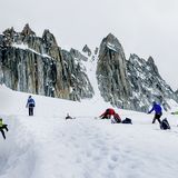
From the Rothornhütte (3197 m) cross north west over the plateau of the Trift Glacier. Bear west and climb the ramp north of the main crevasse zone, near to the rocks beneath Col do Mountet. Remain parallel to the rocks, passing beneath the Trifthorn on a southwesterly bearing until level with the Triftjoch. Now turn south towards the E-Ridge of the Wellenkuppe. Negotiate the bergschrund and climb the final firn flank, from left to right, thus reaching the striking shoulder (ca. 3630 m) at the foot of the Wellenkuppe's East Ridge. 1½ hours.
Foot of the E-ridge - Wellenkuppe
From this shoulder, a broad ledge leads onto the E flank.
Variant a): Many rope teams follow this band and then ascend over the brittle, rockfall-exposed e-flank; there tracks have now formed. This variant is becoming more and more the 'standard route'.
Variant b): Somewhat safer, though also brittle in places, is the original normal route: the E-ridge starts has a vertical step at the bottom. Directly below this steep step, climb diagonally up and left onto the E-flank. Then as soon as possible climb 1 SL over rocky steps into a niche at the foot of a vertical chimney. Up and right of this chimney is a shoulder. Climb the chimney direct (Friend) and then move out right on the shoulder. This brings you onto the broad E-ridge (iron stake). This place is called the "Pulpit". Follow the wide ridge over slabs about 100 m up (partly brittle rock on the slabs, more iron pegs) up to another vertical step. Here again traverse left on a broad ledge.
At this point the two variants unite again (remember this point for your descent). Climb a decent rock section up onto a large block field. Continue across in a W-direction, bypassing yet another small tower system on the left-hand side and ascend to a gap before the last, slabby upswing; a small, steep step which goes at 2c. Then follow the large slabs (peg) though a crack system up to a final rocky platform. From here a short snow crest leads to the tip of the "Wave Crest" (3901 m), 1 hour.
Descent
Down the route of ascent.
Additional information
- Departure point
-
-
- History
-
First ascent probably made by Lord Francis Douglas with Peter Inäbnit and Peter Taugwalder, 5 July 1865.
- Route last update
-
2017


