From Northeast (Oberaarjochhütte to Reckingen) (Normal route) Vorderes Galmihorn 3507 m
-
- Difficulty
- PD
-
- Ascent
- 2:30–3 h, 500 m
-
- Descent
- 4–5 h, 2400 m
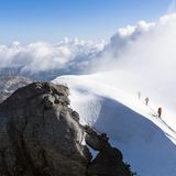
The Vordere Galmihorn is an excellent vantage point due to its outlying position on the southern edge of the Berner Oberland. Not only are there great views of the Finsteraarhorn, Schreckhorn and Lauteraarhorn, but practically the entire Valais Alps and even the distant Mont Blanc present themselves to he or she who stands on this top. The Vordere Galmihorn, though doable is rarely climbed in summer, much more during ski touring season when it is often done as an add-on to the traverse of the Bächilücke. North of the Bächilücke, of course, there is also the Hintere Galmihorn. This summit is hardly climbed in any season.


Route description
Oberaarjochhütte 3256m - Vorderes Galmihorn 3507m
From the Oberaarjochhütte descend into the Oberaarjoch and go down west over the Studergletscher. At the eastern edge of the glacier to the south, at
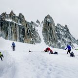
pass east of P. 3060 over the Galmigletscher in the direction of the Vorderes Galmihorn. Take the glaciated N flank up into the Bächilicke (3378 m) and continue over the broad snowy ridge to the summit. Depending on the state of the crevasse zones, it may also be better to ascend further west through the steeper N flank without entering the Bächilicke. (See variant)
Oberaarjochhütte 3256m to teh Vorderes Galmihorn 3507m, variant over the N-flank.
Depending on crevasse zones, consider this variant, further west, climbing more directly up towards the summit and avoiding the Bächlilücke.
Descent over the Bächigletscher (glacier) to end in Reckingen
The descent from the Vorderer Galmihorn over the Bächlicke and the Bächigletscher to Reckingen is often done in winter with skis, but is also possible in summer. Coming from the Oberaarjochütte this results in an interesting crossing.
From the summit of the Vorderer Galmihorn 3507m head north along its broad snow ridge to reach the Bächilücke at 3378m. From here drop down to the east onto the Bächigletscher. This gives but a short steep section of down climbing. Follow the Bächigletscher as it curves more southwards then continue on on the east side of the Bächtales (left in descent) to eventually reach the large earth avalanche retarders, or dams, above Mittelchriz P. 2023. Now take the trail down to Guferschmatte, crossing a small bridge over the Reckingerbach (stream) and later, just south of P. 1790 join a good track through clear cut and young forest to Reckingen. 2200 vertical meters descent; 4 to 5 hours on foot (On skis in winter its hopefully faster!)
Additional information
- Departure point
-
-
- Difficulty
-
The descent from the Bächilicke to the Bächigletscher can be tricky in late summer.
- Waypoints
-
-

