South-east ridge | Mountain hiking | Swiss Alpine Club SAC
Unterstütze den SAC Jetzt spenden

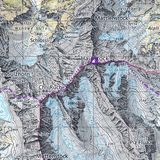
South-east ridge (Normal route) Tschuggen (BE) 2520 m

  • Difficulty
    T4-
  • Ascent
    2 h, 400 m
  • Descent
    1:15 h, 550 m

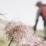
In the midst of the hullabaloo, yet off the beaten track

Tschuggen is beleaguered by ski and chair lifts, and the busy hiking trail between Männlichen and Kleine Scheidegg passes at its foot, yet on Tschuggen one is mostly all alone in the world, despite the faint path on parts of the south-east ridge. Thanks to the lifts and trains Tschuggen is easy to reach. Those who love longer hikes will discover some natural gems albeit the seemingly overdeveloped region. And those who prefer difficulty, will find even alpine terrain to climb on. Besides, Tschuggen can be easily combined with a tour to Lauberhorn.

Route description

Männlichen summit station – Honegg
From the Männlichen summit station hike towards Kleine Scheidegg until Honegg.
Honegg – Tschuggen – P. 2135
From Honegg go up west on grass slopes until the end of the chair lift (not operational in summer) below P. 2333. Continue between rocks and through depressions until you find a faint path, which ascends more or less visible on the south-east ridge or slightly left of it. Occasionally the north-east side drops in a remarkably steep way. A short rocky passage with slabs is easy to overcome – one would hardly use the word „climbing“ –, but it should not be underestimated, as it is slightly exposed, and the hands are needed to help. After this passage there are no difficulties until the summit.
Tschuggen – P. 2135
Descent: The easiest way is to take the same path back to the chairlift, then more to the right through the grassy slopes down to the hiking trail, which you reach again a little south of Honegg, approx. at P. 2135.
P. 2135 – Kleine Scheidegg
Continue on the hiking trail to Kleine Scheidegg.
Variant on the south ridge (also called south-west ridge)
The mandatory climbing passages in the degrees I and II are only short. Apart from that, one can ascend at one’s own discretion in the rugged terrain interspersed with rocks (called „schrofen“) or on the rock proper. There are a few bolts in the rock, but no true belay bolts. The passage offers a welcome opportunity to exercise rope protection in T5 terrain. Walk on the hiking trail from Männlichen to the bifurcation at P. 2121 (Inberg). From there ascend the steep and humid grass slopes to the saddle between Tschuggen and P. 2399. Follow the ridge until below the first rock ribs. At first climb up on the left (west) of the rib until you have the opportunity to traverse to the right. Now continue on scree and grass to a first knoll and then again on grass and climb over the rocky ledge. After a few metres on rocks there is another opportunity to branch off to the right (east) into the schrofen and to follow the rim of the rock rib. At the end hike to the summit on the grass ridge. Ca. 30 min. longer than the main route. T5. This route is also suited for the descent.
Various alternative descents
Towards Grindelwald there is a marvellous descent through Itramenwald, one of the region’s most beautiful forests with its secluded moors and ponds. Proposal: Kleine Scheidegg–Bustligen–Burstblätz–Ufem Unterbrand–Brandegg (Restaurant, stop of Wengernalpbahn). All variants are well signposted.

Additional information

Departure point

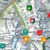
Männlichen, Bergstation (2223 m)

Der Männlichen ist sowohl von Wengen (Luftseilbahn) als auch von Grindelwald (Gondelbahn) erreichbar.

www.maennlichen.ch/de/

End point

Kleine Scheidegg (2061 m)

Difficulty / Material

On parts of the south-east ridge there is a faint path. In addition, you encounter pathless grass slopes and on the ridge a short, slightly exposed rocky passage with slabs, where you must use your hands. Precarious when wet. Those who love even more difficulty, will find a T5 route on the south ridge.

Waypoints

Brandegg (1332 m)

Stop of Wengernalpbahn. Endpoint of one of the variants.

Lauterbrunnen, Trümmelbachfälle (819 m)

Fascinating waterfalls and bus stop. Endpoint of one of the variants.

Neighbor summit

Lauberhorn (2471 m)

It combines ideally with Tschuggen. After descending from Tschuggen hike on the hiking trail until the bifurcation at P. 2121 (Inberg). Choose the trail up, which leads round the south-east ridge of Lauberhorn and meets the marked mountain hiking trail at P. 2214. Follow this trail up to the summit. There are several possibilities to descend to Kleine Scheidegg or Wengernalp (signposts). T2.

Author

Fredy Joss

Sabine und Fredy Joss

Alpine hiking, climbing and other mountain sports Sabine and Fredy Joss's passion. They have been writing and photographing for the SAC publishing house and the club magazine Die Alpen for many years. Sabine is also a biologist and tour guide; Fredy a proofreader and editor for various magazines.

Our recommendations

Skitouren Berner Alpen Ost

Skitouren

Skitouren Berner Alpen Ost

Price CHF 44.00
Member price CHF 34.00
SAC-Crocs

Equipment

SAC-Crocs

Price CHF 59.00
Member price CHF 49.00
Klettern Kombipaket Berner Oberland

Klettern

Klettern Kombipaket Berner Oberland

Price CHF 98.00
Member price CHF 79.00
Tourenportal/App-Abo Jahreszahlung

Subscription to the SAC Route Portal

Tourenportal/App-Abo Jahreszahlung

Price CHF 49.00
Gipfelziele Berner Oberland Grossformat

Berg- und Alpinwandern

Gipfelziele Berner Oberland Grossformat

Price CHF 54.00
Member price CHF 45.00
SAC-Hütten-Monopoly

At home

SAC-Hütten-Monopoly

Price CHF 69.90
Member price CHF 60.00
SAC-Taschenmesser

Equipment

SAC-Taschenmesser

Price CHF 54.00
Member price CHF 49.00
feedback