

![[Translate to English:]](/fileadmin/Der_SAC/Unserer_Partner/CSS_cyan_rgb.svg)
From the summit station of the Matt – Weissenberge aerial cableway Sunnehörnli / Sonnenhorn 2163 m
-
- Difficulty
- PD
-
- Ascent
- 3 h, 990 m
-
- Descent
- 990 m
-
- Exposure
- S, SW
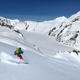
The sunny ascent explains the summit’s name. The gentle landscape is perfect for skiing so it is not surprising that Sonnenhörnli is a popular target.


Route description
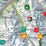
Weissenberge summit station – Sonnenhörnli via Chammplangge
From the summit station of the aerial cableway (1255 m) follow the trail towards Weissenberge for a short distance. At Hoschet traverse the pastures north-westward towards Engisboden. At ca. 1360 m turn eastward across a small bridge to Schiben. Now go north-eastward, passing between Hüsli and the water reservoir (1523 m) to reach P. 1643 through the forest. Continue north on the hiking trail via Chegelboden to the Stäfeli ski hut at P. 1759. Following the alp trails via Bärenboden, you reach P. 1903. From P. 1903 follow the south ridge to reach the highest point of Sonnenhörnli via P. 2163.
Depending on the conditions, you can also ascend slope of Chammplangge.
Variant following the south ridge
From P. 1903 ascend via Matt to 2240 m at Chammplangge. Then turn westward to traverse a steep slope (up to 35°) to reach the ridge a few metres below the summit.
Descent
On the ascent route, the Chammplangge variant only in safe conditions.
Additional information
- Departure and arrival point
-
Weissenberge, Bergstation (1255 m)
Informationen zur Seilbahn Matt – Weissenberge: www.weissenberge.ch/luftseilbahn/
-
- Route number
-
531a


