Traverse West Ridge - East Ridge Studerhorn 3631 m
-
- Difficulty
- PD+
-
- Ascent
- 2–3 h, 610 m
-
- Descent
- 2–3 h, 670 m
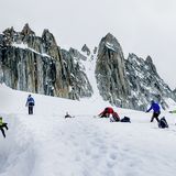
As well as the steeper challenge of the once popular north face, the Studerhorn can be climbed easily from the south. Recommended here is the scenic west-east traverse of its ridge line. The summit, while being lower than its proud neighbour the Finsteraarhorn (4274 m) - the highest peak of the Berner Oberland, is also visible from Bern, and was named in honour of the geologist Bernhard Studer (1794–1887).


Route description
Oberaarjochhütte to the Obers Studerjoch
From the hut head down to the Oberaarjoch and then westwards, later northwest over the gentle slopes of the Studer Glacier (crevasses) and up to the Obers Studerjoch (3398 m); 1½ hours from the hut.
Obers Studerjoch to the Studerhorn (3643 m), and descent to the Oberaarjochhütte.
From the Obers Studerjoch (col) follow the gradual but exposed firn ridge to the summit.
In descent, take the moderately steep snow flank, initially south-east, then more easterly towards the Unders Studerjoch (lower col) at 3356 m. From here, two possibilities are offered:
a) Ca. 300 m east of the Unders Studerjoch (3456 m) descend southwards through a steep channel onto the Studer Glacier (easy with firm snow, otherwise tricky).
b) Continue along the firn ridge to climb Altmann (the Old Man!) at 3462 m. Descend to the east once more along the narrow ridge to the low point between Altmann and the Oberaarhorn. From there drop down a steep snow slope southwards to gain the Studer Glacier (can also be difficult when the snow is gone). Note: It is worth assessing the current situation in the morning while crossing the Studer glacier to help make a right choice. Once on the Studer Glacier coast downhill and then climb the short rise to regain the Oberaarjoch and the hut.
Additional information
- Departure and arrival point
-
-
- Waypoints
-
-

