

![[Translate to English:]](/fileadmin/Der_SAC/Unserer_Partner/CSS_cyan_rgb.svg)
From Weglosen (Normal route) Rütistein 2025 m
-
- Difficulty
- PD-
-
- Ascent
- 2:30–3 h, 990 m
-
- Descent
- 990 m
-
- Exposure
- W
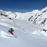
This is a ski tour for beginners, which can be undertaken in practically any weather or avalanche situation. The lower part is on a forest road for quite some time, but the upper part consists of wide-open slopes. Half way up is Druesberghütte. The tour to Rütistein can be combined with a number of easy touring targets such as Biet or Pfannenstöckli.


Route description
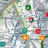
Weglosen – Rütistein
From the Weglosen (1036 m) bus stop ascend through Chäserenwald to Gruebi (1420 m). North of the creek ascend eastward to Druesberghütte. Continue eastward past a small chapel to Pfannenhütten. From there ascend the wide west-facing slope towards the ridge making a wide arc to the right. Overcoming a short escarpment, ascend southward to the highest point.
Descent
On the ascent.
Additional information
- Waypoints
-
www.druesberghuette.ch, call + 41 55 414 11 63
-
- Neighbor summit
-
With a 10 min. detour you reach Pfannenstöckli.
-
- Route number
-
263


