Ober Axen - Rophaien – Lidernenhütte | Mountain hiking | Swiss Alpine Club SAC
Unterstütze den SAC Jetzt spenden

Ober Axen - Rophaien – Lidernenhütte Rophaien 2077 m

  • Difficulty
    T4
  • Ascent
    3 h, 1400 m
  • Descent
    2 h, 665 m

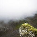
The cross above Lake Lucerne

«The fact that William Tell was one from Uri, pleases old and young in this country.» Not so long ago, namely in 1970, this was written in the hiking guide for the canton of Uri. Therefore we begin at Tellsplatte, where William Tell supposedly, according to the legend and Friedrich Schiller’s play, escaped from Gessler’s boat. We ascend for a long time and increasingly steeply to the sky above Uri, until we cannot go any higher. At Rophaien we get a sense of the freedom that seemed to have been so important for the folk hero and enjoy the breath-taking view down to the landscape the way it is 700 years later. Then we follow an exposed path across ridges so wild one could think they were battered by the oldest Uri phenomenon itself. No, not Tell but the Föhn (strong wind coming down from the mountains, which is called „the oldest Urner“).

Route description

Ober Axen – Rophaien
From the summit station of the aerial cable way Flüelen/Gruonbach–Ober Axen (ca. 980 m) hike to the mountain restaurant Ober Axen and around a clearing to Ober Frimseli (1170 m). The trail zigzags up to ca. 1200 m, passing Ober Frimseli on the south-east, and then turns right to P. 1399. Now hike on a faint, hardly visible path up to ca. 1650 m, where the path turns right. Above a rocky outcrop, at a simple emergency shelter at about 1720 m, the trail turns left continuing steeply, occasionally slightly exposed in grassy slopes to reach the saddle at ca. 1870 m between Blutt Stöckli and Rophaien. The rest of the 200 m is unproblematic. On the north-west ridge the trail leads to the large summit cross on Rophaien (2077 m).
Rophaien - Äbneter Stöckli
An exposed path links Rophaien with Äbneter Stöckli (2087 m). Normally you follow exactly the ridge line using your hands every once in a while, to keep your balance (especially where the trail has collapsed). At first descend a few metres from Rophaien (steel cables helping), then hike through the beautiful landscape around Roten Chöpf, and again with the help of steel cables, but not exposed, ascend to Äbneter Stöckli.
Äbneter Stöckli - Rotenbalm - Zingeli - Lidernenhütte
After Äbneter Stöckli and Diepen keep left to reach Firtiggrätli (1959 m) and then descend to Rotenbalm. On the marked trail from Rotenbalm via Zingeli to the Gitschen summit station (1717 m) of the aerial cable way. Continue above the building to reach Lidernenhütte in about 10 minutes. Variant: at ca. 1760 m traverse to the right to the face in order to go around the outcrop of a mountain top on the north, keeping the altitude (one passage with steel cables). Shortly afterwards you stand before the Gitschen station.

Additional information

Departure point

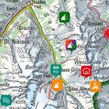
Oberaxen, Bergstation (990 m)

Informationen zur Seilbahn Flüelen – Oberaxen: www.oberaxen.ch/index.php

End point
Time

Ober Axen – Rophaien 3 h.

Rophaien – Lidernenhütte 2 h.

Difficulty / Material

Until P. 1339 the trails are good. Afterwards until ca. 1650 m the path is rather faint requiring some orientational skill. The rest of the ascent to Rophaien is in very steep meadows and slopes where the farmers risk their lives making wild hay: by hand and without any machines. The trail is very precarious in wet conditions. On the ridge to Äbneter Stöckli one follows a narrow, exposed path which is recommended for surefooted hikers in snow-free conditions only. The most challenging passages are the first exposed minutes after Rophaien. From Rotenbalm to Gitschen the trail is marked white-blue-white and has two slightly exposed passages, which can be problematic, when there is old snow (thus until late into the summer), but which can be bypassed with only a minor additional effort.

Waypoints

Luftseilbahn Chäppeliberg (Lidernen), Bergstation (1717 m)

Author

Remo Kundert

Remo Kundert is a hiking guide and owner of the hiking tour operator Per Pedes Bergferien. He also works as a freelance photographer and alpine journalist, and has co-authored numerous hut guidebooks, alpine- and family hiking books.

Our recommendations

Gipfelziele Zentralschweiz Vierwaldstättersee

Berg- und Alpinwandern

Gipfelziele Zentralschweiz Vierwaldstättersee

Price CHF 54.00
Member price CHF 45.00
SAC-Crocs

Equipment

SAC-Crocs

Price CHF 59.00
Member price CHF 49.00
Tourenportal/App-Abo Jahreszahlung

Subscription to the SAC Route Portal

Tourenportal/App-Abo Jahreszahlung

Price CHF 49.00
SAC-Hütten-Monopoly

At home

SAC-Hütten-Monopoly

Price CHF 69.90
Member price CHF 60.00
Schneeschuhtouren Zentralschweiz

Schneeschuhtouren

Schneeschuhtouren Zentralschweiz

Price CHF 59.00
Member price CHF 49.00
Ausbildung Bergwandern / Alpinwandern

Ausbildung

Ausbildung Bergwandern / Alpinwandern

Price CHF 59.00
Member price CHF 49.00
Hütten der Schweizer Alpen / Cabanes des Alpes suisses

Bildbände

Hütten der Schweizer Alpen / Cabanes des Alpes suisses

Price CHF 69.00
Member price CHF 59.00
feedback