From Station Rotenboden via the East-Ridge and the North Flank. (Normal route) Riffelhorn 2930 m
-
- Difficulty
- F, 2a
-
- Ascent
- 1–1:30 h, 168 m
-
- Descent
- 54 m
From the station Rotenboden you go to the start of the Riffelhorn and climb over several rock steps to the highest point. The station Rotenboden (2815 m) can be reached with the Gornergratbahn.

Route description
Station Rotenboden - Riffelsee
The station Rotenboden (2815 m) can be reached with the Gornergratbahn.
From there, a footpath leads south past the Riffelsee.
Riffelsee - Riffelhorn
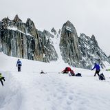
From the Riffelsee, ascend slightly to the foot of the E-ridge of the Riffelhorn, where the climbing begins (about 2820 m), ½ hour. Below this ridge there is an ideal practice area for beginners in the form of small easy angled slabs and short steeper steps. On the left (S) below the start there is also a single pitch sport route (5c).
To begin, a slabby groove leads up rightwards onto the E-ridge (grade 2). (This first step can also be avoided by following an easy ledge left into the S-face before reaching the E-ridge at its end without much difficulty). Follow the ridge until the second big step. Here descend about 10 m northwards to reach a ledge that bypasses the step. At the end of this ledge, climb 3 meters higher to another, broad and scree covered ledge. This traverses parallel to, but slightly below the main ridge, across the N-flank until the third and final big step. This is climbed on its NE side, first over some steps, then via a left trending corner to reach the E-summit (grade 2). A broad straightforward ridge then leads to the W summit (2930 m), ½ hour.
Descent
Follow the route of ascent.
Additional information
- Departure point
-
Rotenboden (2815 m)
Information about the cable car Zermatt - Rotenboden: www.gornergratbahn.ch/de/sommer/bahninformationen/
-
- History
-
The Riffelhorn was formerly visited by hunters. The official ascent was probably over today's 'Normal Route', made by John Barwell, Lushington, Valentine and William Smith, with unnamed guides, on 8 August 1842. First ascents of the numerous other climbing routes can not all be identified or named.


