From Suen across Pas de Lovégno Pointe de la Tsevalire 3025 m
-
- Difficulty
- F
-
- Ascent
- 5–6 h, 1600 m
-
- Descent
- 1600 m
-
- Exposure
- W, NW
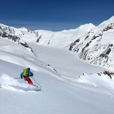
It is a long tour in a terrific landscape, which stirs feelings of solitude. The summit is accessed over the long western ridge.


Route description
Suen - Pas de Lovégno
From Suen - St-Martin (1429 m) ascend to the chalets of Les Tsijeraches (1605 m). Cross the road and traverse the long clearing until its upper end. Now follow a wide ridge to Plan Zenevrec (2253). This point can also be reached from the road further up leading to the pastures (in winter groomed as far as Buvette Grange Neuve, 1647 m). From there ascend obliquely on a foot path to Prabé (1946 m). After traversing the forest, turn left to join the route coming up from Suen at Plan Zenevrec. Continue on a ridge between the rocky humps Les Réchasses (2431 m and 2521 m) to reach a terrace at the foot of the western ridge of Becca de Lovégno (2555 m). Leave this long ridge to the left and ascend south-eastward on characteristic, terraced and large slopes to Pas de Lovégno (2695 m).
Pas de Lovégno – summit
From the col descend slightly south-eastward to the top step in the upper Val de Réchy. Continue on very gentle slopes towards Pointe de la Tsevalire, the triangular summit at the end of the valley. At an altitude of ca. 2800 m keep southward to reach the col Grand Bandon (2833 m) and the wide western ridge. Depending on the snow conditions the last stretch may be negotiated on foot.
Descent
On the ascent
Additional information
- Waypoints
-
-
- Catering and overnight stay
-
Cabane des Becs de Bosson (2985 m)
It is possible to reach Cabane des Becs de Bosson from the summit. Continue eastward on the ridge and across Col de la Tsevalire (2946 m). Difficulty: WS +.
-
- Route number
-
540d


