![[Translate to English:]](/fileadmin/Der_SAC/Unserer_Partner/CSS_cyan_rgb.svg)
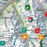
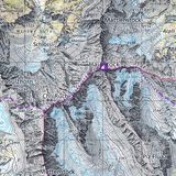
Comologno – Pizzo Ruscada – Monte di Comino (Normal route) Pizzo Ruscada 2003 m
-
- Difficulty
- T3
-
- Ascent
- 3:45 h, 1300 m
-
- Descent
- 2:15 h, 1240 m
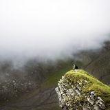
From the jungle up to the vantage point and down to the high plateau
In Ticino the land covered by forest has trebled to 150 000 hectares since World War II, and it is still increasing, as in high altitude the land is less and less cultivated. 50% of the entire territory of the canton is covered by forest; that makes Ticino the most forested canton of Switzerland. Since December 2002 the upper Valle Onsernone has the second largest forest reserve of the country. The route presented here shows us the different biospheres of the reserve, from the deep, wet gorge to the arid terrain on the ridges and up to the alpine summit region of Pizzo Ruscada. On the way you will come across a stock of white fir of European importance. The white fir survived the last ice age ca. 15 000 years ago in various refugia; one of them is southern Italy. From there it spread out back to the Alps. On its way north it formed variegated stocks on the south side of the Alps, and therefore the white fir in Valle Onsernone genetically differ from those on the north side, which had survived in another refugia. The one in the south cope better with climate change, for example, which could be important for the survival of the species in the future.


Route description
Additional information
- End point
-
Monte di Comino (1155 m)
Bergstation der Seilbahn vom Bahnhof von Verdasio her. Information über die Seilbahn und Unterkünfte unter www.comino.ch und www.montecomino.ch
-
- Time
-
Comologno – Pizzo Ruscada 3 h 45 min.
Pizzo Ruscada – Monte di Comino 2 h 15 min.
- Difficulty / Material
-
There are no technical difficulties, but some wet, slippery passages when crossing the Isorno. On the descent from Pizzo Ruscada you come across some boulders which require caution. Briefly before Pizzin the well-maintained hiking trail traverses a short, slightly exposed rocky ledge.
- Waypoints
-
-