![[Translate to English:]](/fileadmin/Der_SAC/Unserer_Partner/CSS_cyan_rgb.svg)


Via the South East Ridge. (Normal route) Mittaghorn (Lötschental) 3892 m
-
- Difficulty
- PD, I
-
- Ascent
- 2–3 h, 670 m
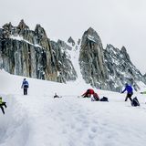
In Switzerland there are maybe a dozen mountains over 2000 meters with the name Mittaghorn. By far the highest is the one described here in the chain from the Jungfrau to the Tschingelhorn on the Bern-Wallis border. As with the other Mittaghorns (or Midday Peaks), it gets its name because the sun is seen to be above the summit at noon from a certain vantage point, in this case from the Lauterbrunnen valley. In good conditions this can be a short and rewarding tour from the Hollandiahütte. However with strong "Ausaperung" - melting of the snows due to radiation, the bergschrund beneath the Anujoch or the final ridge can prove problematic.


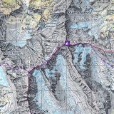
Route description
Additional information
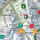
- Departure point
-
-
- Difficulty
-
However with strong "Ausaperung" - melting of the snows due to radiation, the bergschrund beneath the Anujoch or the final ridge can prove problematic.
- Waypoints
-
-
- History
-
First ascent made by Charles Montandon, A. Ringier und Adolf Rubin on 19. August 1878.