From the East Lötschentaler Breithorn 3785 m
-
- Difficulty
- PD-
-
- Ascent
- 5–5 h, 1390 m
-
- Descent
- 250 m
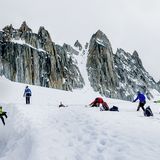
A rather long tour starting at the Oberaletschhütte, mostly on the glacier. The key passage is overcoming the steep section to the south of the Lonzahörner. Depending on the condition of the glacier it can be tricky or (if all the surface snow is gone) even impossible. The hut warden at the Oberaletschhütte is always willing to give sound advice here. A scenic tour in the heart of the heavily glaciated Oberaletsch Basin. An interesting addition to the tour would be to descend via the Gredetschjoch (saddle) and from there through the lonely Gredetschtal (valley) to the village of Mund.


Route description
Additional information
- Departure point
-
-
- Time
-
Je nach Ausaperung und Zustand Gletscherbruch kann die Begehung deutlich mehr Zeit beanspruchen.
- Difficulty
-
Der Zustand des Gletscherbruches kann erheblichen Einfluss auf die Schwierigkeit haben oder eine Begehung sogar verunmöglichen.
- History
-
J. Häberlin with A.& J. von Weissenfluh and J. Rubin, 28. August 1869.
- Route last update
-
Dezember 2017

