From Näfels Lochegg 1535 m
-
- Difficulty
- PD-
-
- Ascent
- 5 h, 1250 m
-
- Descent
- 1250 m
-
- Exposure
- N, E, S
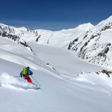
If there is sufficient snow, you can traverse Lochegg from one side to the other. This is an example of how to enhance an easy ski tour with some creativity and the use of public transportation.

Route description
Näfels – Lochegg
From the Näfels, Freulerpalast (ca. 440 m) bus stop, walk through the village westward and on the summer hiking trail ascend a steep slope in the forest. Bypass Brandbödeli to the north-east to reach Bränden via P. 749. Continue to reach the Näfels – Schwändital road, then go southward to cross a bridge. Ascend on the road and the hiking trail to Eggberg (1084 m). On the ridge of Näfelser Bergs go westward via Boggenhöhi (1256 m) to the highest point of Rossweid (ca. 1330 m). In the pasture ski down north-north-eastward to Twing (1174 m). Depending on the conditions, you can take a taxi to reach this point. Following the road, ascend via Schattenstafel, Sonnenstafel, Winteregg and Oberlochegg to reach Lochegg.
Descent to Oberurnen
Ski down the beautiful slopes of Mittlere and Untere Lochegg. Continue past Tschingel and Bränden to the Oberurnen, im Horn bus stop .
Additional information
- Remarks
-
There is a bus on request to Twing (1174 m) from the Näfels-Mollis railway station. Call the day before to make reservations: + 41 55 612 10 72
- Route number
-
405

