From the Cabane de Chanrion via the South West Ridge (Normal route) La Ruinette 3875 m
-
- Difficulty
- PD, 3a
-
- Ascent
- 5:15–6 h, 1450 m
-
- Descent
- 50 m
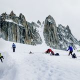
La Ruinette is the highest point between the Grand Combin and the Dent d'Hérens. The panorama from the summit is impressive. The classic route of the illustrious first ascent is a bit lonely now due to the glacier conditions also more difficult. Starting from the Cabane de Chanrion you follow a footpath to the Col de Lire Rose. This is indicated on the newest maps as P. 3065, but the actual crossing is E of it at P. 3115. You then follow the SW ridge or the firn fields of the Glacier de la Ruinette to the summit.


Route description
Cabane de Chanrion - Col de Lire Rose
From the Cabane de Chanrion (2462 m), head north to P. 2519, where you cross the road. Soon after follow the lefthand fork down to a bridge (2521 m) over the Dyure du Brenay (stream). After that climb easily to the Col de Tsofeiret (2628 m). There you go to the right towards the old lateral moraine of the Glacier du Brenay, past the lake 2722 m, and crossing P. 2838 onto a steep scree flank, over which you reach the Col de Lire Rose (3114 m), 2¼ hrs.
Col de Lire Rose - La Ruinette
From the Col, follow the ridge to P. 3386. Then, depending on the conditions, climb the S-ridge (max grade 3) via P. 3470, or move out early onto the firn fields of Glacier de la Ruinette. Continue in the firn flank, passing P. 3710 on the right, and join the summit ridge at the point where it steepens. Climb the ridge (grade 2) to the highest point (3874 m), 3 hrs.
Descent
Follow the route of ascent or from Tsofeiret directly to Mauvoisin.
Additional information
- Departure point
-
-
- Waypoints
-
-
-
The route reaches the col at P. 3114.
-
- History
-
Edward Whymper with Christian Almer and Franz Biner, 6. July 1865 (via the Glacier de la Ruinette).


