From Hienzi (Mels) Garmil 2002 m
-
- Difficulty
- F
-
- Ascent
- 3:30 h, 1150 m
-
- Descent
- 1150 m
-
- Exposure
- N, NW
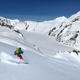
Starting from the road through Weisstannental, Garmil is the target of a popular ski tour. The starting point can easily be reached by bus from Sargans or Mels. This tour can be undertaken even in unfavourable conditions, as it is generally on gentle terrain and in the upper part follows a ridge. Safe conditions, however, are required for the continuation to the neighbouring Gamidaurspitz or the descent via Geissloch to the Wangs/Pizol skiing area. Please respect the game reserve areas to the left and right of the official itinerary!


Route description
Hienzi – Garmil
From the bus station Mels, Hienzi (ca. 850 m) ascend south-eastward, cutting some bends on the summer hiking trail, to reach the pastures of Ebenwald. Now in open terrain ascend south-eastward past the chalets at P. 1409 via Hinterwald to reach an altitude of ca. 1630 m. There is a short stretch through the forest, then follow the sparsely forested ridge from Burst to Fürggli (1744 m). Continue on the ridge to reach the highest point of Garmil.
Descent
On the ascent; please respect the game reserve areas to the left and right of the official itinerary!


