Western ridge (from Gyrshubel) | Mountain hiking | Swiss Alpine Club SAC
Unterstütze den SAC Jetzt spenden

Western ridge (from Gyrshubel) Gandhore 2111 m

  • Difficulty
    T4
  • Ascent
    2:45 h, 1550 m
  • Descent
    3:30 h, 1510 m

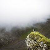
An unobtrusive, unknown summit, but an absolute must

Many summits' names nobody knows, never make it into a tour guide and are climbed rather accidentally, although they stand in an attractive landscape, have interesting routes on ridges and on faces and are simply beautiful peaks. Gyrshubel and Gandhore are among those mountains which deserve to be visited more often.

Route description

Blankenburg – Chalet P. 1799
From Blankenburg follow the marked mountain hiking trail towards Ussers Heuw-Eggli: at first (along Betelriedbach) on the road, then just before the bridge branch off to the right and up Grueholz to Alp Vehsattel (1711 m). Before the chalets turn right (south) on an old alp trail, which leads to another group of buildings (1799 m). Follow this trail as far as the chalet. Short cut: take the Alpentaxi to the bend at P. 1457: saves ca. 1 h 30 min.
Chalet P. 1799 – Gyrshubel – Gandhore
In front of this chalet (1799 m) leave the trail and hike pathless through pastures and sparse forest, then continue on steeper grass slopes until the ridge between P. 1915 and Gyrshubel. A faint path along the ridge leads up to the summit. The Gyrshubel ridge with its splendid view is a destination in its own right. So far: T3. From Gyrshubel follow the ridge eastward towards Gandhore. The ridge becomes rocky and very brittle. Nevertheless, it is easy to hike. Keeping slightly to the right (south) of the ridge, one reaches the saddle at P. 1920. Continue along the ridge and ascend until you reach a rock structure. Make a detour to the left on the western face to avoid some rocks. Scramble up between two rocky steps. The route is obvious and easy to find thanks to a faint path. Above this steeper part continue to the summit on or slightly left of the exposed ridge. Not only the panorama is very impressive, but also the dizzying view deep down the south face to the vast scree at its foot, the result of the brittle rock of Gandhore. Descend the same route to the Chalet at P. 1799.
Chalet P. 1799 – Vehsattel P. 1711 – Ussers Heuw-Eggli – St. Stephan
Ascend from Alp Vehsattel to the right (soutt-est) on the mountain hiking trail to Ussers Heuw-Eggli (1966 m), then continue south and south-west to descend via Gandbode to St. Stephan. Those who want to stop at an inn must do so in Grodey, as at the station there is only a vending machine. From Alp Vehsattel one can descend to Alp Vehsattel and hike back to Blankenburg on the mountain hiking trail; saves about 1 hour as compared to descending to St. Stephan.

Additional information

Departure point

Blankenburg (960 m)

An der MOB-Linie Zweisimmen – Lenk i.S.

End point

St. Stephan im Simmental (994 m)

An der MOB-Linie Zweisimmen – Lenk i.S.

Difficulty / Material

It is a hike on a ridge where climbing is unnecessary, but a few passages require scrambling, where the help of the hands is necessary. Especially Gandhore, which has fairly exposed passages just below the summit. Being sure-footed and unafraid of heights is crucial. Slippery when wet. There are only intermittent faint paths. For Gyrshubel: T3.
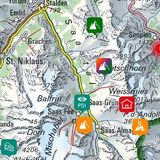
Waypoints

Gyrshubel (1968 m)

This summit is traversed on the way to Gandhore, but it is a rewarding destination in its own right. At T3, it is slightly easier than Gandhore.

Ussers Heuw-Eggli (1966 m)

This col is crossed on the way down to St. Stephan.

Various

Variant traverse Gandhore north flank

The traverse of the Gandhore north flank proposed in the guidebook Alpinwandern Gipfelziele "Berner Oberland" is no longer recommended or described for reasons of wildlife protection. The tour as described here is half an hour longer.

Neighbor summit

Mieschflue (Färmel) (2154 m)

It can be reached within 45 min. on a marked mountain hiking trail from Ussers Heuw-Eggli. Beautiful vantage point, which can be climbed on the Gandhore tour, provided that the hiker has some stamina left. The descent via Färmeltal to Matten (train station) is also possible. T2.

Authors

Fredy Joss

Sabine und Fredy Joss

Alpine hiking, climbing and other mountain sports Sabine and Fredy Joss's passion. They have been writing and photographing for the SAC publishing house and the club magazine Die Alpen for many years. Sabine is also a biologist and tour guide; Fredy a proofreader and editor for various magazines.

Sabine Joss

Our recommendations

Skitouren Berner Alpen Ost

Skitouren

Skitouren Berner Alpen Ost

Price CHF 44.00
Member price CHF 34.00
SAC-Crocs

Equipment

SAC-Crocs

Price CHF 59.00
Member price CHF 49.00
Klettern Kombipaket Berner Oberland

Klettern

Klettern Kombipaket Berner Oberland

Price CHF 98.00
Member price CHF 79.00
Tourenportal/App-Abo Jahreszahlung

Subscription to the SAC Route Portal

Tourenportal/App-Abo Jahreszahlung

Price CHF 49.00
Gipfelziele Berner Oberland Grossformat

Berg- und Alpinwandern

Gipfelziele Berner Oberland Grossformat

Price CHF 54.00
Member price CHF 45.00
SAC-Hütten-Monopoly

At home

SAC-Hütten-Monopoly

Price CHF 69.90
Member price CHF 60.00
SAC-Taschenmesser

Equipment

SAC-Taschenmesser

Price CHF 54.00
Member price CHF 49.00
feedback