From Capanna da l’Albigna via the Bocchetta dal Castel (Normal route) Cima di Castello 3378 m
-
- Difficulty
- PD+, 3a
-
- Ascent
- 4–5 h, 1200 m
-
- Descent
- 1200 m
Long but relatively straightforward tour to the highest summit of the area. The Cima di Castello can also be done during a hut to hut tour via the Passo dal Cantun, when changing from the Albignia- to the Forno hut (or reverse).


Route description
Capanna de l'Albigna - end of the footpath
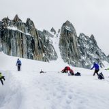
From the Albigna hut, follow the path leading south, down to the reservoir. Cross the bridge and ascend the opposite scree slope on the northern flank of Punta da l'Albigna. Follow tracks around the western buttress of Punta da l'Albigna, then head along beneath the south facing walls to reach the glacier.
End of the footpath - Bocchetta dal Castel
Head southeast beneath the south facing walls of Punta da l'Abigna towards the Vadrec del Castel Nord glacier. Bear southwards over the glacier to reach the saddle, Bocchetta dal Castel, at 3104 m
Bocchetta dal Castel - Cima di Castello
From the saddle, Bocchetta dal Castel (3104 m), either ascend the west ridge directly, or drop down slightly to its southern side and ascend via the west flank. A final short section of ridge provides the crux (2a) where the greatest difficulties are avoided by keeping left (east).
Descent
Follow the route of ascent. Or descend to Passo dal Cantun and descend the Vadrec del Forno gacier to reach the Forno hut.
Additional information
- Departure point
-
-
- Time
-
Ca. 170 m altitude gain from the glacier stream up to the Albigna hut if returning there.
- Waypoints
-
-
- History
-
FA made by D.W. Freshfield and C.C. Tucker with François Dévouassoud and Alexander Flury on 31. July 1866.

