
![[Translate to English:]](/fileadmin/Der_SAC/Unserer_Partner/CSS_cyan_rgb.svg)


From Spina and Pian San Giacomo (Normal route) Cima de la Bedoleta 2626 m
-
- Difficulty
- PD+
-
- Ascent
- 5 h, 1460 m
-
- Descent
- 1460 m
-
- Exposure
- N, NE, E
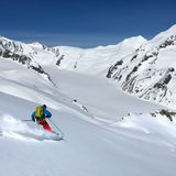
The ascent from Spina or Pian San Giacomo is multifaceted: the first steep stretch through the forest is followed by the wide, open summit slopes. Exiting from the forest, one reaches the I Cebi huts. A few metres below the summit is the Pian Grand cabin. There are actually two pyramidal constructions, mainly built to be used in summer for hikers on the "Sentiero alpino Calanca". If there is little snow, the last part of the ascent is scrambling on blocks. Sufficient snow is required, if you want to ski all the way down to Spina.


Route description
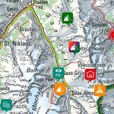
Spina - Cima de la Bedoleta
If travelling by car, begin the tour at the artificial lake at Spina (1189 m). Go around it to ascend the pastures of Corina to Scot (1326 m). You can reach the same point by following the forest road. North of Cif the two routes meet.
Following the summer trail, ascend to Pignela Sora (1453 m). From here ascend the steep (passages with 30°) and sparse forest until the I Cebi hut (1721 m).
Alternatively, ascend directly through the steep forest to P. 1602 and traverse the ditch of the creek below I Cebi.
Now traverse the terrace between the hut and the creek and westward ascend the steep slope (32° - 34°) until ca. 1950 m. Now exit from the forest to ascend the open slopes towards Alp d'Arbeola (2080 m). Ascending south-westward and past P. 2182, you reach the high plain between Piz Pian Grand and Alta Burasca. Now ascend the north-east-facing slopes to Bivacco Pian Grand (2398 m) located near a tiny lake. Then ascend southward to reach the steep east-facing slope (30° - 32°) which leads to the summit.
Variant using the bus: Pian San Giacomo – Scot
If travelling by bus, the starting point is the Pian San Giacomo Paese bus stop. From there descend to the bridge across the Moesa (ca. 1170 m). Now follow the trail and the forest road, which leads to Scot via Turgegn.
Descent
On the ascent


