![[Translate to English:]](/fileadmin/Der_SAC/Unserer_Partner/CSS_cyan_rgb.svg)


Descent from Chöpfenberg Chöpfenberg 1894 m
-
- Difficulty
- T4
-
- Descent
- 1:15 h, 660 m
The first bit of descent is steep but equipped with fixed chains. Thereafter a faint track leads down steeply to the pass, where one joins the ascent path.


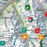
Route description
Chöpfenberg - P. 1587
From the summit cross, move left along the east ridge (marked white-blue-white) then turn right and descend the south flank, in 2 or 3 places steep but protected with chains, to the cliff base (T4). A faint track lead 200 m along the base of the cliff in the direction of Brüggler before dropping down steeply through grass to P. 1587 on the watershed between Schwändital and Trepsental.
P. 1587 - parking
Follow the ascent path easily back to the parking.
Additional information
- End point
-
-