![[Translate to English:]](/fileadmin/Der_SAC/Unserer_Partner/CSS_cyan_rgb.svg)
From Habkern Bolberg 1799 m
-
- Difficulty
- F
-
- Ascent
- 2–2:30 h, 800 m
-
- Descent
- 800 m
-
- Exposure
- SE, SW
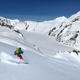
It is a rewarding round trip, which can be undertaken after heavy snowfall, when elsewhere the avalanche risk is too high.


Route description
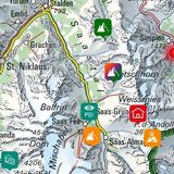
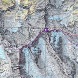
Habkern – Bolberg
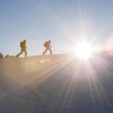
From the Habkern, Post (1067 m) bus stop follow the alp access road to Troubachbrücke (1041 m) and traverse the gorge of the Bolbach on the road. As soon as possible ascend eastward in open pastures to P. 1454 on Schwendiegg via Lischere. Following the ridge, you reach the flat Winterröscht summit (1758 m) after a short passage through the forest. This point is also reachable from Lombachalp. Follow the marked snowshoe route (ca. 30 min.).
From Winterröscht descend westward to Läger (1722 m) and continue in the same direction to reach the wide summit of Bolberg (1799 m).
Descent from Bolberg via Bolsiten
From the highest point of Bolberg (1799 m) ski down northward through a sparse forest to reach the alp access road, which leads from Bolsitenallmi to Widegg. More or less on the road, ski down in hilly forested terrain to reach the building on Bolsitenallmi (1467 m). Continue to descend to the Heubühlen (1331 m) alp via Egg. Now follows a short, but rough escarpment, which is best overcome on the right-hand side of a haystack (not visible from above). Continue in pastures to reach Lammsbrügg. On the road descend south-eastward to Bohlseite (1108 m). If there is sufficient snow, you can ski down on the summer trail directly to Troubachbrücke (1041 m).
Additional information
- Remarks
-
The Swiss Ornithological Institute runs a protection program in the area for capercaillie. Please do not stray off the route described here!
- Waypoints
-
-
- Route number
-
150