

![[Translate to English:]](/fileadmin/Der_SAC/Unserer_Partner/CSS_cyan_rgb.svg)
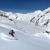
From the Mittelallalin summit station (Saas-Fee) Allalinhorn 4027 m
-
- Difficulty
- PD+
-
- Ascent
- 2 h, 570 m
-
- Descent
- 2200 m
-
- Exposure
- NE, W
The route goes up the N side of the Feegletscher. To reach the Feejoch, it travels between a few large transversal crevasses. From Feejoch it goes up the W face. To reach the top, a slight turn to the right must be made .


Route description
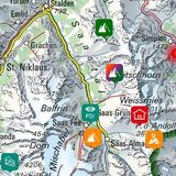
Mittelallalin – Feejoch
From the Mittelallalin station (3456 m) of the Alpin Metro ski down on the run. After crossing the ski lift ascend south-westward (caution: seracs), then continue depending on conditions on the fall line which avoids a crevassed zone. After this zone ascend in the bowl leading up to Feejoch (3807 m).
Feejoch – Allalinhorn
From Feejoch ascend the W face, either on foot or skis, depending on the conditions. Then bypass the summit structure to the east to reach the summit.
Descent
On the ascent, then continue to Längflue or Felskinn and Saas Fee on the ski runs.
Route variant
Depending on the danger of crevasses or icefall, this route is suitable.
Additional information
- Departure point
-
Mittelallalin (3456 m)
Saas-Fee – Mittelallalin: www.saas-fee.ch/en
-
- Waypoints
-
-
- Route number
-
270


